All posts by Gavin Fry

Sept. `17-24th Active Severe Weather

Well, it sure has been some time since we’ve talked about severe weather potential. I’ve been in Europe this summer preoccupied with other things, but now I’m back in Northeast Arkansas, and there is some active severe weather this week. More so in the great plains and into the Ozarks, but it’s certainly possible we get some severe weather here in the Mid-South more towards the latter part of the week (24th or so).

I’m going to update this post over the next few days (I’m writing this on Wednesday September 20th, 2023, at 1:42pm Central time). As of now, I’m planning on going storm chasing in the Tulsa area this Saturday (on the 23rd), but we’ll see how things shape up over the next few days. Let’s start with the Day 1 (Wednesday 20th) outlook from the SPC:

The biggest severe potential today (only a marginal risk 1/5) is in the ArkLaTex region and southeastern Oklahoma.

Day 2:

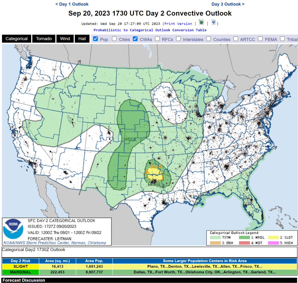
Day 2 is a little more promising on the severe weather front, with two primary regions of a threat in the northern Great Plains and Southern Oklahoma with the threat of large hail and damaging winds.

Day 3:

There’s also a slight risk for severe weather on the Day 3 outlook for parts of South Dakota, Nebraska, and Northern Kansas with the primary threat being damaging winds.

Day 4-8

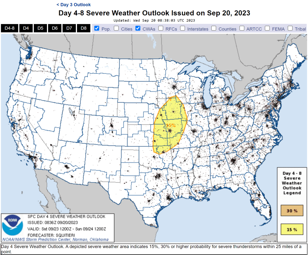
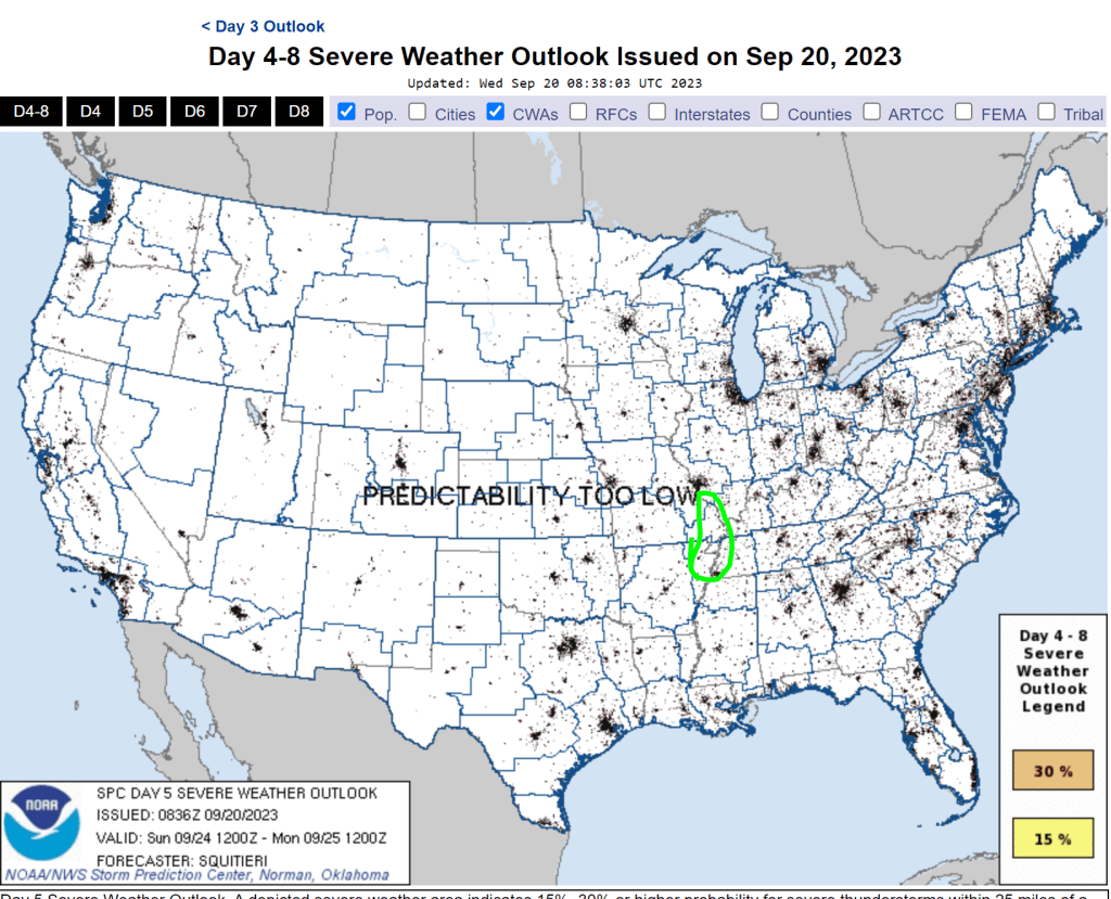
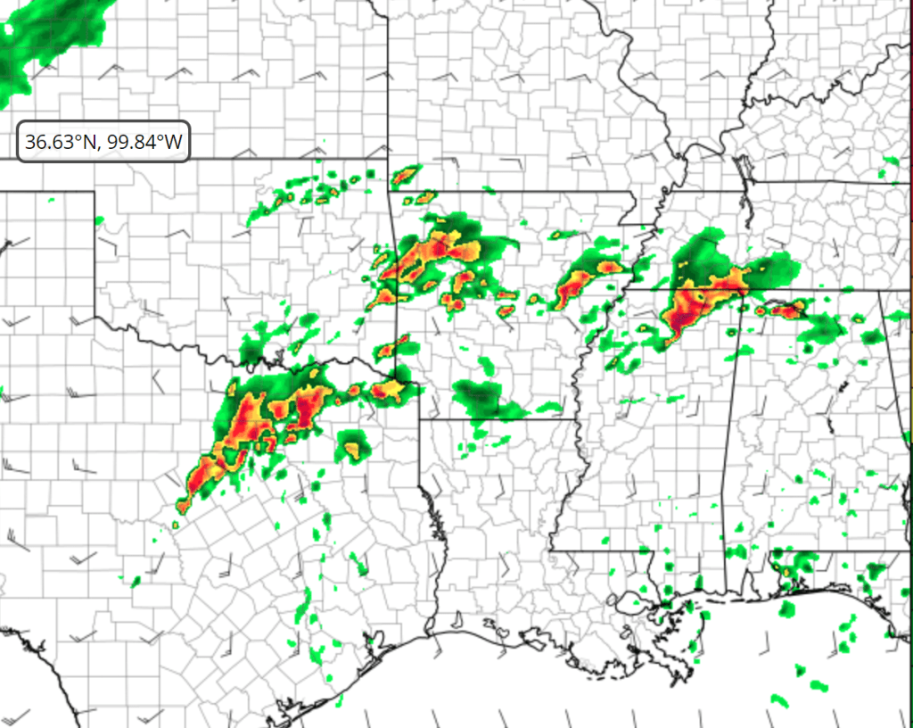
I’m watching the Day 4 – 8 outlook very closely, as it seems there’s growing confidence in severe potential throughout the Northwest MO region and into parts of Iowa, Kansas, Nebraska, and Oklahoma. This might be the day (saturday evening) were I start the storm chasing. Let’s look at some of the model data from the GFS:

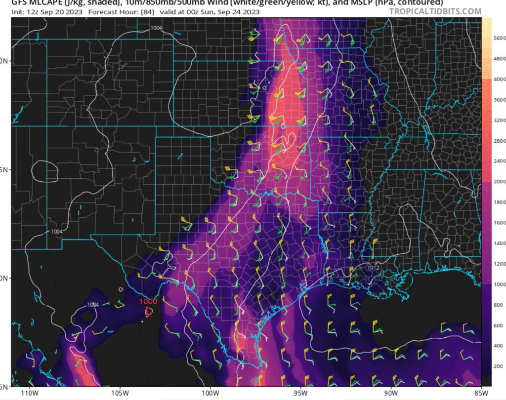
The GFS is putting out a moderate swath of CAPE (Convective Available Potential Energy) and decent shear profiles for Saturday evening (the above image is forecasted for 7pm Central time). We’ll see how this turns out. Let’s try and make a forecast for Day 5, 6, and 7.

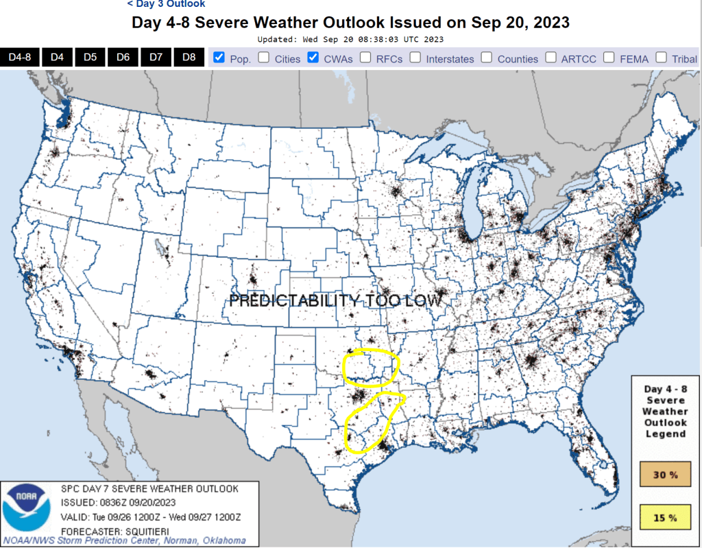
I’m just going to base this on the forecasted CAPE and shear profiles as in the Day 4 outlook:

Day 5

Day 6

Day 7

We’ll certainly be watching this as it unfolds, and I’m grateful that you’re coming along for the ride! Stay tuned!!

Tuesday 4/4 -4/5 Severe Wx Outbreak

4/2/23 11:03AM

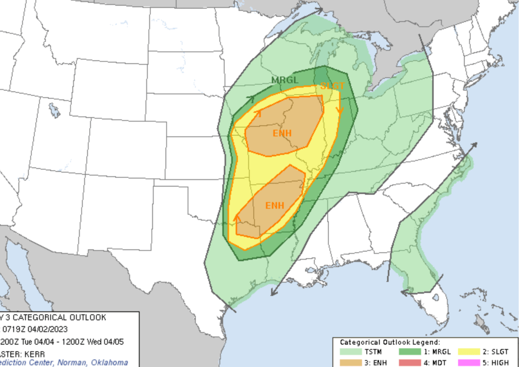
Well…. here we go again. Just finished wrapping up the post for the 3/31/23 outbreak in the Upper Midwest and the Mid-South, and we’ve got another enhanced risk three days out. Oddly enough, it’s resembling the setup that we just saw with this past event. Here’s the SPC Day 3 convective outlook for this event:

I won’t speculate on the specifics of this setup until tomorrow, but the parameters are coming together. For the southern ENH region, the SPC’s discussion mentioned the dependency on moisture availability ahead of the initiation. From the 06z run of the GFS on 4/2, it seems that there will be decent moisture availability up the Missvly with Dewpoints generally in the mid-60s.
forecasted for 8:00PM 4/4/23

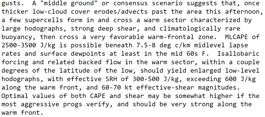
The moisture obviously increases buoyancy and needs to be paired up with the wind shear to create a robust severe setup, so we’ll have to see. Here’s a bit of language from the SPC:

Stick with me and we’ll see how this unfolds. Will update!

//UPDATE// 4/4/23

I am writing this on Tuesday April 4th 2023 at 10:21 EDT. The SPC has issued a moderate risk for portions of the Upper Missvly and parts of the southern plans and south. The timing of this setup seems to be biggest question. Here’s the day 1 convective outlook from the SPC:

To add to this graphic, here’s some language from the SPC:
*Note that there is already a moderate risk issued….

Here’s some more language from the talk about the northern moderate risk region:

“Climatologically rare buoyancy….”

3/31/23 Mid-South and Midwest Severe Weather Outbreak

Well…. here we go again. Not even a week after the severe event I reported on in my last post, we’ve got another chance for all modes of severe weather in the Mid-South and the upper Mid-West. I am writing this initial post at 10:20 A.M. EDT on 3/30/23 here in Hanover, New Hampshire. I wish I could be back at home for this event, chasing these storms. However, I will have to observe from afar and warn as many family members as I can.

As of this morning, the SPC has issued a moderate risk for northern portions of the Mid-South in the MO bootheel, parts of KY, NE Arkansas, and West Tennessee for tomorrow 3/31/23. It seems that these locations are primed both in terms of shear and instability (more shear than buoyancy), but it seems that the ingredients are certainly coming together:

We can compare this moderate risk in the Mid-South region to the December 10th, 2021 outbreak which produced that long-tracked EF-4 across the Mid-South and into Kentucky. I’m not sure the kinematics or thermodynamics are the same (I think there was much more instability on the 10th), but the rough shape of the moderate risk and location is very analogous…. interesting stuff.

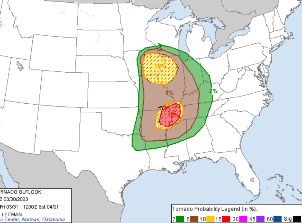
In terms of categorical risk, there is a hatched 15% tornado risk for the lower-portion of this powerful mid-latitude cyclone:

This is probably due to a more favorable shear profile in the Mid-South than further north.

Now, I’d like to touch on the SPC and NWS station discussions for this event, particularly for MEG.

The SPC uses the language of “a concerning scenario” for the Mid-South region. I’m obviously so focused on this region because that’s my home, so I’m a little biased, but the SPC language is right there:

This discussion is just scary and so freaking interesting to me… based on some of the higher resolution models that the meteorologists are probably looking at, it looks exactly spot on. The NWS-Memphis office put out a discussion that I thought was very interesting… here’s a portion of it:
This is equally fascinating. Depending on the amount of surface heating throughout the day, that might determine just how bad this setup will be. If the “junk” convection is limited throughout the day…. then, well, let’s just pray I suppose. Based on the HRRR and NAM 3km, there does seem to be a good amount of cloud cover throughout the preceding night and early morning with breaks in a few spots.

Again… only time will tell. Just texted my good friend Arianna at OU as well…. she says, depending on the factors I just listed (junk convection), we might just have the first HIGH RISK of the season. (Would that be the first high risk in a couple years??) This is epic, but totally scary and could be devastating.

Will update!!

//POST-STORM UPDATE// 4/2/23

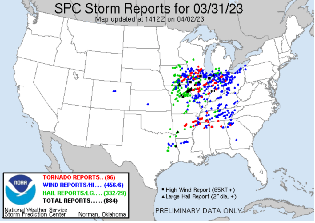
I’m writing this at 10:38AM EDT, two days after the destruction of this outbreak. Folks at home in the far northeastern AR region and the MO bootheel were pretty much unscathed, thankfully. However, communities in the Wynne, AR, area were absolutely devastated. NWS crews are currently surveying the damage. I’m anticipating an EF-2 or 3. Here’s the SPC storm report map for the day:

Overall, the SPC did a damn good job at forecasting this thing. The northern extent of the moderate risk down south might not have been warranted, but the high risk in the Memphis region was spot-on. Thankful to the NWS, emergency response, and cleanup crews for their efforts. What a storm.

Signing off for this one,

Gavin

3/24/23 Severe Weather Outbreak in the Ark-La-Miss and Mid-South

I am writing this on 11:44AM CDT in Paragould Arkansas on 3/23/23. There is a slight risk of severe thunderstorms extending from central TX to NE Oklahoma throughout the day today. However, the big event isn’t forecast until tomorrow afternoon and evening.

Currently, there is a moderate risk of severe weather including all hazard types (damaging winds, strong tornadoes, and large hail) across the greater Ark-La-Miss region for the late afternoon / evening hours of Friday March 24, 2023.

Looking at some of the model guidance, there seems to be a decent capping inversion at the surface around the region in question. However, there also seems to be a lot of conditional instability aloft that these storms can tap into if they break the capping inversion.

Based on some of the higher resolution model forecasts for the 12z run on the 23rd, the cells propagating ahead of the cold front seem to be in line with the SPC’s moderate outlook with a more congealed frontal threat further north away from the more robust buoyancy.

This could be a notable event, and I’m going to chase regardless. I’m sure the NWS will put out a spotter activation any time today or early tomorrow. I will wait on updated model guidance to see where I need to situate myself because I feel that a discrete supercell or two might find their way just under the Bootheel in that Monette, Blytheville, and Osceola region. I will try my best to report any severe weather concerns to the NWS while getting good pictures! Stay tuned…. Will update.

// BRIEF UPDATE // 3-24-23 12:37AM

I’m writing a very brief update after reading the updated version of the Day 2 outlook from the SPC which stated that the moderate risk could be extended a bit further north due to better severe weather parameters. I will look into this in more detail tomorrow morning. This could end up being a very notable severe weather event…. only time will tell.

//Post-Storm UPDATE// 3/26/23

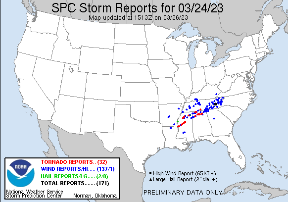
I’m sitting here back in college at the dining hall after storm chasing less than 36 hours ago. It wasn’t as bad further north into the moderate risk area, but the bullseye in west-central Mississippi was devastated. Here is the map of the storm reports:

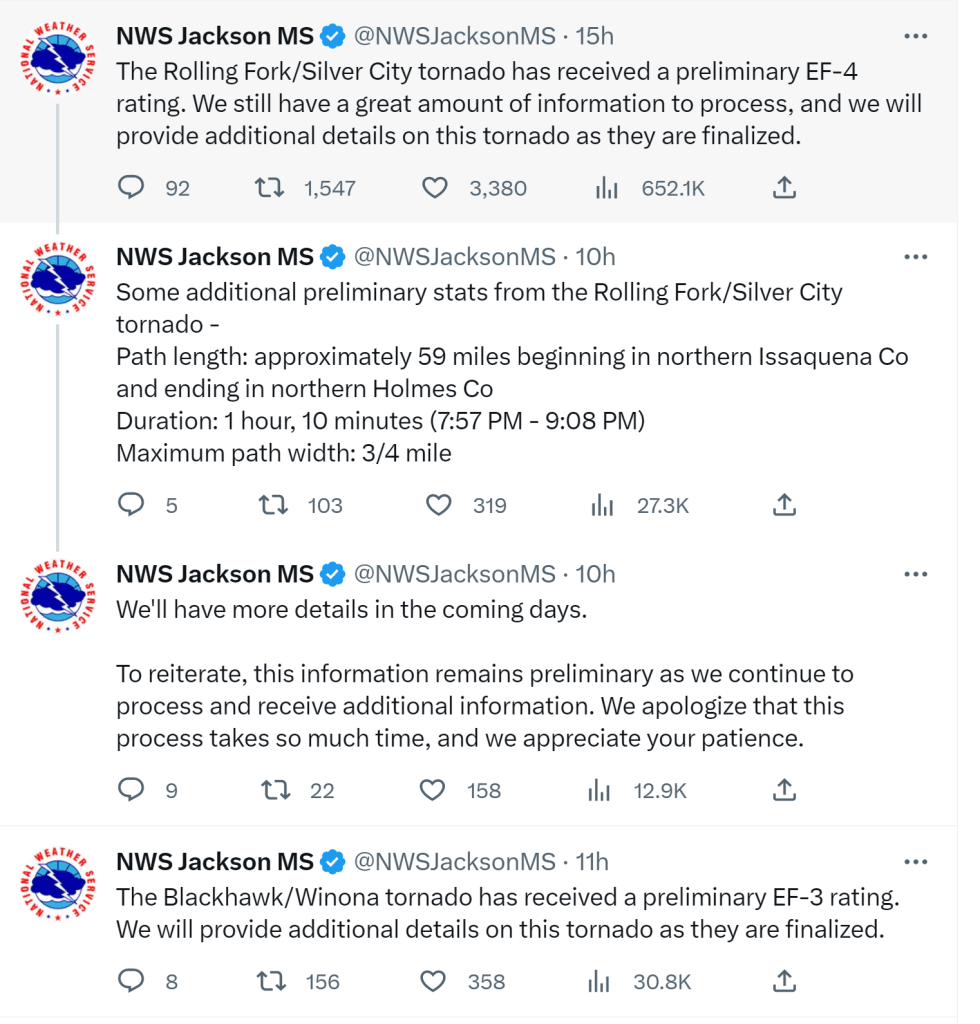
The NWS-Jackson MS twitter page talks about the preliminary ratings of tornadoes that killed almost 30 people Friday night:

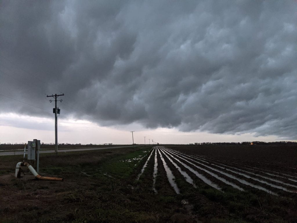
Dad and I managed to stay pretty far north of the chaos, but we managed to capture some pretty pictures of lightning and clouds while we were there. Praying for the families of the lost loved ones. It’s our reminder that we are subject to mother nature’s power.

That’s all she wrote folks…

March 1st / 2nd 2023 Severe Wx Outbreak in the South

Time: March 1st, 14:25 EST Hanover, New Hampshire

Content: A widespread severe thunderstorm outbreaks seems likely later this evening and especially tomorrow evening and low-level moisture and high lapse rates encroach on the deep south. The SPC currently has a moderate risk issued for the 2nd day convective outlook for the ArkLaTex region.

Here’s the convective outlook for later this evening on March 1st:

The enhanced risk was just updated this early afternoon. Looking at higher resolution model data, it seems that a few cells may pop up toward the 4-5 PM hour and converge into something resembling a MCS across central and northeast Arkansas (below Jonesboro) later this evening. Shear doesn’t look too bad, but I wouldn’t be surprised if something pops up in that “Manilla, Lepanto” corridor that always seems to get severe weather. Definitely look at radar later to see what’s going on today. A few cells behind the initial system seems likely too, although the severe threat by then seems to have dissipated.

For March 2nd, the SPC has issued a moderate (4/5) risk for severe thunderstorms with all hazards possible. A few cells initially pop up in central/southern Arkansas, and then a blast of storms out of SE OK and NE Texas takes over and brings the bulk of the severe weather. More messy rainstorms further toward the MO / AR line, but the parameters seem to be in place for a notable event. We’ll examine more in detail as we get closer to the event.


Here’s the high res forecast for 3:00PM EST on March 2nd. CAPE values 1500-2000 in the ArkLaTex region and moderate sheer.

November 29th 2022 Severe Wx Outbreak

It’s been a while, but this event is certainly worth of a post, and then some (probably). The SPC noted a risk of severe weather in the 4-8 day outlook earlier this weekend. Now, they’ve issued a moderate risk of severe weather (4/5) with the potential for hail, damaging winds, flash flooding, and potentially long-track powerful tornadoes.

The CAPE associated with this event doesn’t seem record-breaking, but the shear-favorable environment may lead the supercells that form to spawn these strong tornadoes. This time, I’m going to be looking at this event from inside the ring. Namely, I’m going to be working at the NWS-Memphis office for several hours tomorrow getting to see what goes on the inside. I’m looking forward to working with these incredible scientists to hopefully help save some lives.

The SPC has issued the following statement at of 4:00PM CST on 11/28:

“Severe thunderstorms capable of producing tornadoes and wind damage, along with some hail, are expected Tuesday afternoon and evening, extending into the overnight period across parts of the lower to mid Mississippi Valley and parts of the Southeast. A few strong/long-track tornadoes will be possible.”

I had an amazing time at the NWS this week. Although this system tended to underperform in the Memphis CWA, the Jackson MS office got most of the action with several tornadoes and a few fatalities. I’m surprised we only seen a few; this was a textbook nocturnal tornado outbreak in the deep south. We are lucky!

FYS Paper #2

Prompt: To what extent are citizens influenced by information from the political world versus being beholden to prior attitudes or dispositions (e.g., partisanship)? In answering this question, you are expected to draw upon the readings we have discussed to this point in the class (no external reading is required).  Your paper should be 3 pages, double-spaced.   

And here is the full text:

Gavin Fry

Professor Jerit

Does Democracy Work?

13 February 2022

Paper #2

            Political information can and should inform public opinion. However, citizens’ prior attitudes and predispositions dictate how they process new information. Those with strong attitudes are likely to hold onto their prior beliefs. Therefore, they are more resistant to new information changing their opinions. Likewise, citizens are motivated to seek out information that aligns with their beliefs and dismiss opposing information (Lodge and Taber 2006). It is difficult for people to set aside personal biases and view new information through an objective lens in today’s political climate. Information can inform U.S. citizens, but facts come with interpretations that cater to prior beliefs and personal biases.

            John Sides’s empirical study on public opinion of the estate tax shows that information can influence people. Most voters supported the repeal of the estate tax, even though the tax affected only the wealthiest individuals in the nation (Bartels 2004). In Sides’s 2007 study, he showed that only 40 percent of people supported the estate tax with no information (as a control). However, 51 percent of people supported the estate tax after receiving information about who pays the tax (Sides 2016, 398). Likewise, 62 percent of people supported the estate tax when presented with facts and rhetorical arguments for and against it. Therefore, facts can help people differentiate between less and more compelling arguments. Sides showed that facts could, theoretically, influence public opinion.

            However, people’s prior attitudes and beliefs dictate whether information can influence their opinion. Lodge and Taber (2006) note that, “Ideally, one’s prior beliefs and attitudes… should ‘anchor’ the evaluation of new information and then, depending on how credible some piece of evidence is, impressions should be adjusted upwards or downwards” (755). Unfortunately, this idealized model is not the reality. Instead, people operate with disconfirmation and confirmation biases that lead to attitude polarization (Lodge and Taber 2006). For instance, people denigrate information and arguments that do not align with their prior attitudes (Lodge and Taber 2006). The stronger the prior attitudes, the less likely one is to evaluate new information objectively. Additionally, more people seek confirmatory information around their issue attitudes than opposing information (Lodge and Taber 2006). Lodge and Taber’s findings were most prominent among the politically sophisticated – those who have the strongest attitudes and motivation.

            How can we reconcile both Sides and Lodge and Taber’s empirical studies? Sides showed that factual information could influence public opinion. However, Lodge and Taber find that preexisting attitudes – and subsequent biased information processing – limit the influence of new information. Sides’s empirical evidence is valid in an idealistic sense. The participants received information about who pays the estate tax, and many shifted their views. Sides reaches an optimistic conclusion that people can be influenced by facts, even above rhetorical arguments. I agree with the notion that information can influence public opinion, but the structure of this study does not represent the real-world conditions that lead to attitude polarization. People regularly seek information that aligns with their interests (Lodge and Taber 2006). Citizens rarely encounter isolated facts about an issue in today’s political world, as Sides presented them. Information readily available today is rarely given as straight facts. Most often, interpretations of the facts bolster disconfirmation and confirmation biases. Therefore, even if information (isolated facts) influences public opinion in a controlled, experimental sense, as in Sides’s study, predispositions outweigh factual influence in today’s political world.

            Today’s political environment caters to people’s prior attitudes and bolsters biased reasoning. Sides’s study dismisses the fact that most people seek out information that aligns with their prior attitudes (Lodge and Taber 2006). Consequently, people encounter information with interpretations that cater to their belief system. Lodge and Taber’s study better represents the “real-world” conditions that lead to attitude polarization (2006). They show that people operate with confirmation and disconfirmation biases that may reject new information. Sides’s findings are relevant in a theoretical sense; however, people do not receive isolated facts around an issue in today’s media environment. They dismiss challenging information and absorb information that aligns with their predispositions. As a result, people’s beliefs will stay fastened to prior attitudes, and their rigidity suppresses openness to new information.

            People can be influenced by unbiased political information, but today’s political climate makes it difficult. Citizens are motivated to seek out information that confirms their prior beliefs. Additionally, people view opposing arguments and information through a biased lens (Lodge and Taber 2006). If people are influenced by information today, they must set aside prior beliefs and be open to new information. Today’s polarized political climate dampens the ability to be flexible in one’s beliefs. To summarize, information can persuade the U.S citizenry. However, it is up to the individual to set aside prior attitudes and be flexible in their beliefs to allow new information to inform them. Unfortunately, prior beliefs and attitudes influence people more than information in modern society.

References

Bartels, Larry M. “Unenlightened Self-Interest.” The American prospect 15, no. 6 (2004): A17–.

Krosnick, Jon A. “Government Policy and Citizen Passion: A Study of Issue Publics in Contemporary America.” Political behavior 12, no. 1 (1990): 59–92.

Sides, John. “Stories or Science? Facts, Frames, and Policy Attitudes.” American politics research 44, no. 3 (2016): 387–414.

Taber, Charles S, and Milton Lodge. “Motivated Skepticism in the Evaluation of Political Beliefs.” American journal of political science 50, no. 3 (2006): 755–769.

March ’22 Wx Archive

DateTmaxTminTobsSnowSnow D. “PrecipWx
3/1/2231328T4TFlurries
3/2/22352232T4TPC.
3/3/223323230.24″0.02Clear
3/4/2228-3280.04″0.00Clear
3/5/22395380.03″0.00PC.
3/6/225931580.01″0.06Clear
3/7/225937390.000.32drizzle
3/8/225029M0.000M
3/9/22372230TTTlgt snow
3/10/224624450.000Clear
3/11/224723470.000PC.

February ’22 Wx Archive

DateTmaxTminTObsSnowSnow D.PrecipWx
2/1/2232-1290.007″0.00Ovc.
2/2/224328420.006″0.00PC.
2/3/224435390.004″0.08Light rain
2/4/2240192110″14″1.39″Light snow
2/5/222110170.5″15″0.02Clear
2/6/2224-9210.0014″0.00PC
2/7/22325320.0014″0.00Ovc.
2/8/22392935T13″0.15Ovc.
2/9/224120390.0013″0.00Clear
2/10/224225400.0011″0.00Clear
2/11/224829450.009″0.00Clear
2/12/225040440.008″0.00MC.
2/13/224417260.007″0.00Clear
2/14/22278130.006″0.00Clear
2/15/2224-5230.006″0.00Clear
2/16/2239-1380.006″0.00PC.
2/17/225535510.005″0.00Ovc.
2/18/225324250.001″0.45Clear
2/19/22299260.51″0.02Md. Snow
2/20/22274270.51″0.03PC.
2/21/224323420.0000.00MC.
2/22/224224380.000TMist
2/23/225836420.0000.75Clear
2/24/224311280.0000.00Clear
2/25/222814196.570.49Md. Snow
2/26/22280260.050.00Clear
2/27/22351630T4TMC.
2/28/22316210.040.00Clear